Drones now capable of counting stock
Added 6 months ago
By Hawke's Bay Future Farming Trust

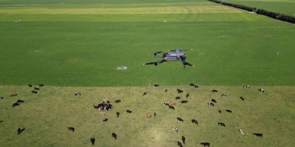
The process of counting livestock for annual audits has received a technological upgrade, with drones now equipped to identify and record stock numbers using artificial intelligence.
A partnership between PGG Wrightson and tech company Inde has introduced SkyCount, a system that simplifies stock auditing. Using Microsoft Azure and Power Apps, the solution reduces the task to a 30-minute operation with a single drone operator and 97% accuracy.
Inde, based in Christchurch, operates across various sectors, including agriculture, in New Zealand and Australia. Inde's Chief Technology Officer, Rik Roberts, explained that they have been collaborating with PGG Wrightson for nearly seven years on this project. PGG Wrightson sought to explore whether drones and AI could streamline the stock counting process.
The autonomous drone system now flies over paddocks, recognizing and counting livestock for auditing. This innovation significantly reduces the manpower and time required for traditional stock audits, which typically involve multiple people and an entire day of herding livestock.
PGG Wrightson CEO, Stephen Guerin, emphasized that while stock audits are crucial for their farmer relationships, the process can often be time-consuming and disruptive, especially if interrupted by factors like weather. The SkyCount project, developed since December 2022 and launched at Fieldays, is now part of PGG Wrightson’s service offerings. Guerin noted that this technology eliminates the need to physically move animals, making the process far more efficient.
Beyond annual audits, farmers can also use the technology after weather events or when selling a farm. Roberts explained that the system uses machine learning to identify livestock by analyzing thousands of images to teach the AI what a sheep or cow looks like, even when partially obscured.
For hill and high country terrain, the drone maintains altitude using lasers to measure distance from the ground, and geo-positioning technology helps accurately identify livestock. The system can be used for both sheep and cattle, with future applications envisioned for surveying, digital mapping, and crop health.
During stock counting, the farm is mapped using GPS with centimeter-level accuracy. The drones are designed to avoid disturbing the livestock, and the flight path is optimized to avoid flying too low. Once stock numbers are recorded, data is processed and stored via Microsoft Azure. The results are presented to farmers as graphs or dashboards, with reports automatically generated and emailed.
Join the conversation
Be the first to leave a comment.
Leave a comment
All comments are reviewed before they are published on the website. Your email address will not be published.


Family-Owned Farm Embraces Regenerative Agriculture to Grow and Educate


